Back then, no one I talked to could explain its origin, nor did the Birwood Wall show up in survey maps or in city histories. So, one drizzly November morning in 1991, I set out on a door-to-door search along Birwood Street to track down the wall’s history. After numerous blank looks and puzzled head shakes I finally located Alfonzo Wells, then in his seventies with white hair, blue eyes, and dark skin. He’d lived in this Northwest-side community since 1942.
“Been here half a century and nobody never asked about that wall,” Wells told me. As he pulled on a pair of yellow rain boots, locked the door to his bungalow, and joined me for a walk along Birwood, he explained that the wall had been raised in the early ’40s to block the spread of a small, isolated black community into the surrounding white neighborhoods. The establishment of a black island on this side of the city, outside the sprawling Eastside ghettoes of the day known as Paradise Valley and Black Bottom, had alarmed white homeowners, who envisioned encroaching crime and disorder. Many blacks who had bought land to build homes in this area had been turned down for Federal Housing Authority loans; with so many vacant lots and already foreclosed homes by the early ’40s, the area was considered “blighted.”


Besides, with the wartime housing boom on, and not much other vacant land remaining in the city, the area around Birwood was ripe for development. The black enclave was less than a mile west of the rolling lawns and three-story mansions of Palmer Woods and Sherwood Forest, then two of Detroit’s most exclusive white neighborhoods. When a white developer was denied financing to build an all-white subdivision just west of the black community, he and the FHA reached a compromise: in exchange for federal loans and mortgage guarantees, the developer agreed to construct that half-mile-long barricade along the property line, fastidiously dividing blacks and whites.
Alfonzo Wells had vivid memories of the early years when four-man police patrols used to drive down 8 Mile Road, turn south, then cruise the white side of the barricade, tagged “The Wall of Spite” in 1941 by the Detroit Tribune, a black-owned weekly. “If the big four spotted you where they figured you had no business being,” Wells said, “there’d be a head beating.” In the mid-50s, when whites were lighting out for the suburbs, blacks bought up the now empty houses on the other side of the wall. Northland, the first enclosed shopping mall in the U.S., was built nearby, just north of 8 Mile, drawing shoppers from the city in a trend that ultimately left Detroit’s formerly gracious department stores derelict hulks like its factories.
As Wells and I walked along Birwood Street that rainy November morning, I caught glimpses of the wall’s ramparts through driveways and alleys. What struck me at the time was how sturdy, unbroken, and undaunted the wall remained, and how bare– even of graffiti, its symbolic meaning apparently lost on all but a few old-timers. “Yep. Nobody around here remembers why that danged thing was put up,” Wells told me. “But in ’89, when they was raising all that sand about the Berlin Wall coming down, it came to me that this wall here was put up for the same purpose.” His hand shot out toward a length of wall behind two tidy frame bungalows. “Only our Berlin Wall’s still here.” Wells shook his head ruefully. “A long time ago some of us tried to get it tore down, but the city claimed we’d have to pay for it.”
In her 1977 memoir Walk Quietly through the Night and Cry Softly, Burniece Avery, a former resident of the black community around Birwood, describes how her neighborhood group, the Carver Progressive Club, tried repeatedly to prevent the construction of the wall and later campaigned to have it demolished “We talked with the man who is head of the developing company,” Avery writes. “He said the wall is on HIS [sic] property, and there wasn’t anything we could do about it. He further said that he was forced to shut off the view of our dilapidated houses to increase his chances of selling [his FHA-approved] homes.”
As it turns out, the Birwood Wall is no isolated phenomenon, neither in the city’s past nor in its contemporary landscape. Most of the city’s racially inspired barriers still perpetuate what remains a city of walls in the nation’s most rigidly segregated metropolitan area.
Some of these “walls” are merely border streets, like 8 Mile Road, which forms a boundary between the city of Detroit and its northern suburbs, such as Ferndale, Oak Park, and Warren. Six to eight lanes wide along much of the border, 8 Mile Road satisfies a fervent suburban desire for distance from the city that came in first in this year’s Forbes magazine “Miserable Cities Index,” the same year that Detroit became the largest American city ever to file for bankruptcy. But this attitude has at times cut both ways. During the ’70s and ’80s, Coleman Young, Detroit’s first black mayor, delighted in taunting suburban whites with his favorite injunction to get out of the city: “Hit 8 Mile Road” — walling out the suburbs even as the suburbs had walled out Detroit.

A few blocks southeast of the Birwood Wall, a ten-foot-tall solid wood fence runs for a quarter-mile along Pembroke Street. Put up in the early ’40s like the Birwood Wall, the fence marked the boundary between black-owned houses near the 8 Mile Line and the white-owned properties further south on Outer Drive, then a shady parkway lined with new spacious middle-class homes. Black residents were proud of their own brightly painted frame houses, Burniece Avery writes in her memoir. “They had felt that it was an insult to have a wall built to separate them in this manner.” Avery recalls the concern of the Northwest-side black community and describes how she and several neighbors tried to arrange a meeting with a Mr. Slatkin, the developer who erected the long stockade fence along Pembroke. Avery recounts how the builder brushed off the black homeowners. “East is east and west is west and never the twain shall meet,” Slatkin reminded them.
Like the Birwood Street homeowners, few current Pembroke residents are aware of the original motivation behind the odd, unbreached feature that lines their backyards. But when I recently returned to Pembroke, a street I’d so often walked with my two boys more than two decades ago, I spoke with a few people who recalled the controversy and still considered the thing “Slatkin’s Fence.” Howard Paris, tall with dark-framed glasses, remembered that racial tensions were simmering in 1957 when he moved into one of the new duplexes built along the fence that he calls the stockade, saying, “They were all Caucasians on the other side, mostly Jewish. There was a lot of prejudice. The stockade was supposed to be like a barrier. It was deliberately built to separate black from white. There was no outlet — no way to get through it or over it. Only white on the other side and only black on our side.” Parris turned to the fence that still separates the Pembroke houses and the sprawling apartment complex beyond. “The Slatkins were bitterly against us moving in,” Parris said. “They figured if they put up the stockade nobody would build on this side. They built it good and high. I’m six feet tall, and I sure can’t see over it.”
In the ’80s, one of my sons received a scholarship and left the Detroit city school system to attend a middle school in Grosse Pointe. His daily route to school took him from our Northwest-side home near the Pembroke fence and the Birwood Wall, along the 8 Mile Line and across a network of one-way streets, concrete barriers, and membership-only waterfront parks that to this day separates Detroit from its eastern suburbs. Those streets that do traverse the border move through some of Detroit’s most abject Eastside slums into the green and pleasant land of the Grosse Pointe, which is among the nation’s most affluent suburbs. The abrupt change of landscape that accompanied my son’s morning commute occurs at Alter Road, a dividing line between the overwhelmingly white Grosse Pointe suburbs and eighty-five percent black Detroit. Locals refer to Alter Road, like 8 Mile Road, as the Line.


In the 70s, in the aftermath of the 1967 racial upheaval, the City of Grosse Pointe Park shut down Alter Road at the its border. Over the next few years, many barriers were raised, and additional streets were walled off and turned into dead ends. Thoroughfares like 8 Mile and Alter Roads, originally arbitrary lines on a map, became “a chasm between two social classes,” as Tamar Jacoby writes in Someone Else’s House: America’s Unfinished Struggle for Integration. “In some places, usually where the road was wide, it divided slum from new upscale housing development. At other spots, once similar houses on either side of the street now looked like pictures before and after a natural disaster.” Not only were streets clamped off, concrete barriers were also erected to further curtail interaction. Besides these barriers, walls, and dead-end streets still lining Detroit’s east side, a long sweep of high chain-link fences now separates Detroit and Grosse Pointe Park at the riverfront.
While researching the history of Alter Road, I came across a contemporary rock group named Alter Bridge and discovered that the name had been chosen by the group’s leader and guitarist, Mark Tremonti, who had grown up in affluent Grosse Pointe and whose parents forbade him to cross the bridge into Detroit. Like most other suburbanites, Tremonti’s parents regarded Detroit as a landscape of unknowns and dangers. The bridge on the edge of the unknown represented for Tremonti the sense of exploration and experimentation that he sought in his music. Wondering whether such a bridge actually existed, I set of to look for it. Driving east across the city and following the borderline along Alter Road, I found it: a mere hump of concrete spanning narrow Fox Creek Canal, where two decapitated and limbless torsos had been discovered by a fisherman the previous summer.
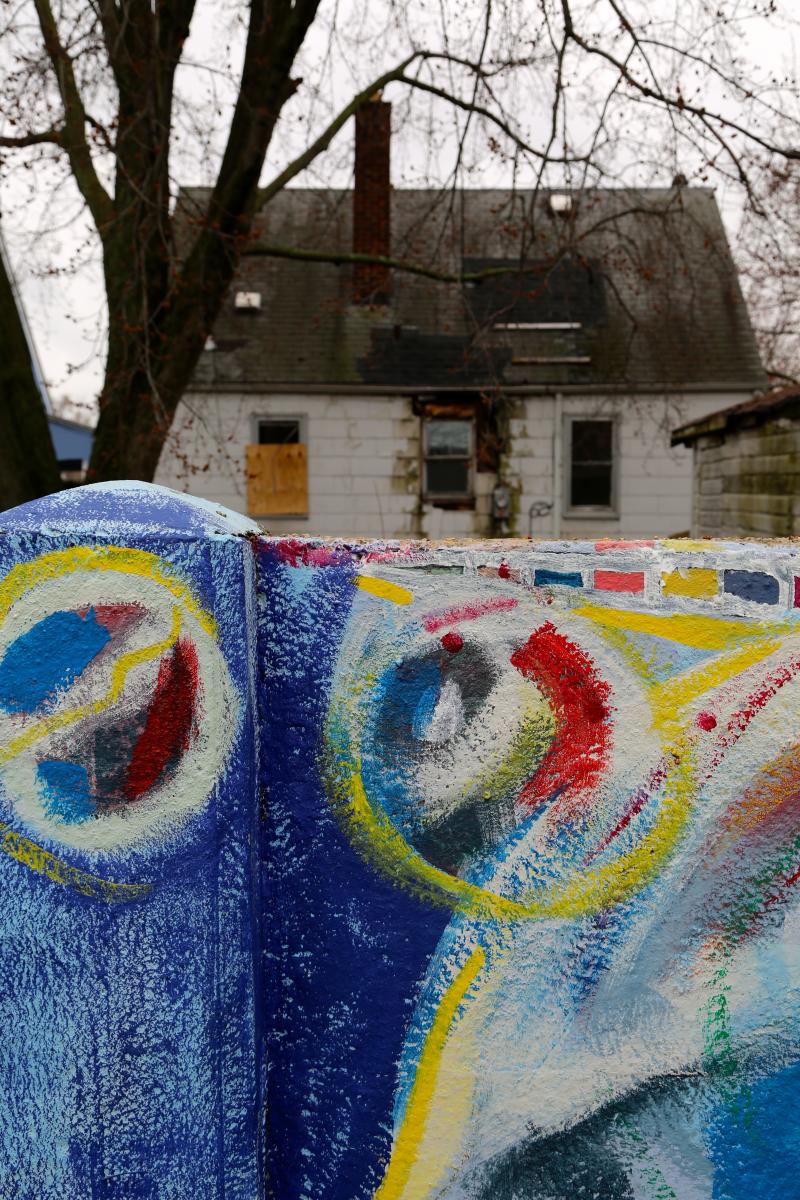
Then I headed back across town to the Birwood Wall in my old Northwest Detroit neighborhood. Retracting the route I’d taken with Alfonzo Wells that damp November morning in the ’90s, I found the landscape little changed — a vista of small well-kept bungalows, alternating with burned-out or boarded-up buildings and trash-strewn vacant lots. An overcast sky glowered down on that stark concrete wall that still marched for a half-mile behind houses on Birwood Street. No children played in the park where an upended shopping cart lay rusting in the gathering rain.

But a fresh-painted sign announced “Alfonzo Wells Memorial Park,” and that section of wall that runs through the ghost park had been transformed into a gallery of portraits, protest scenes, and abstract designs in a rainbow of colors. As I drove back towards 8 Mile along the opposite side of the wall, I glimpsed more painted concrete behind houses — images of children and trees and multicolored flowers. Between two houses, the wall had been transformed into a backyard barbeque pit, and someone had draped the family’s washing over the fortifications to dry. A well-loved line of poetry came to mind. “Something there is that doesn’t love a wall, that wants it down.” Further on, a tunnel had been sledgehammered into the Wall of Spite.
Carolyn Kraus is a longtime Detroit-based teacher, journalist, and co-founder of the Journalism and Screen Studies Program at the University of Michigan-Dearborn.
Photographs by:
Jim Gilmore is a documentary filmmaker, educator and associate professor of Journalism and Screen Studies the University of Michigan-Dearborn.
First set of black and white photographs from the Smithsonian Institute.